 |
|
| |
View previous topic :: View next topic |
| Author |
Message |
desertgirl

Joined: 19 Jan 2003
Posts: 3350
Location: Chandler, AZ
|
 Posted: 4/6/2007, 4:34 pm Post subject: Another Grand Canyon treasure trove: The Gems Posted: 4/6/2007, 4:34 pm Post subject: Another Grand Canyon treasure trove: The Gems |
 |
 |
|
|
[center:198d4992d5]Another Grand Canyon treasure trove: The Gems [/center:198d4992d5]
Topaz, Sapphire, Turquoise, Ruby, Emerald, Jade, Jasper
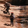
..The area west of Boucher Trail is studded with canyons that bear the names of precious gems What really is precious here is the availability of water! This section of the Grand canyon is particularly arid with very few reliable water sources along the Tonto and limited access from the Tonto to the river. The area is remote with limited trail traffic, trailhead access off the beaten path. Early spring allow us a delightful foray into the tranquil canyon and remoteness the cooling temperatures and winter melt feeds the side canyons the Gems glimmer with strands of water; the toads come out and play, bare winter branches burst forth with fuchsia blossoms and lime green glows on the fresh growth - spring is in the air.
Gems were the final section of the official Tonto trail (New Hance Garnet) that I had to complete. A December visit to the BCO resolved some scheduling issues we were facing in getting a rather luxurious 7day 6 night permit for late March and soon 6 were canyon bound for another adventure. Life intervened for a number of the original group 5 of us made the trip Tim, Tommy, Jim, Ambika and Guru.
An early drop off at the Bass TH and a quick pre-hike group shot; had the group on the trail 8;15 am! A quick descent to the red juniper covered Esplanade, an easy meander across the red rock, a brief stop at the turnoff for the Royal Arch Route and a leaky bladder fix for Tim; a peek down a possible shortcut at the head of Bass Canyon and soon we were contouring along the Supai layer and then a rather vegetated descent through the Redwall. The Bass Canyon Fault Zone makes for a friendly break in the Redwall we were soon heading down along a rather moderated downhill. The redbuds were blooming and fresh lime foliage heralded the on-set of spring.
Guru and I took it easy (Yeah! Packs were heavy, the light delightful and we savored spring) while the rest of the gang fleet footed to Bass Beach. We stashed some water at the intersection of the Tonto East which we will traverse on tomorrow. We reminisced our last descent down the Bass West Tonto shortcut (the shortcut, is marked by a large Tapeats sandstone block separated from the main rim.) that capped off a long day from Garnet to Bass Beach
http://www.arizonahikers.com/forum/viewtopic.php?t=3757&highlight=royal+arch
. We lunched at an overlook that showed a stunning monocline layers of rock parallel so far making a 90 degree dive along the fault zone.( late Precambrian Unkar Group - rocks were folded and faulted more than 700 million years ago)A gentle breeze and overcast sky called for some napping along the way
The trail soon hits the Tapeats and crisscrosses he canyon bed several times through layers of twisted / folded rocks and polished rock surfaces. The cool rock surfaces right before the 1st pouroff need some more full body contact  ; Soon we were on the trail to the bass beach that takes off on the east side ( does cross over a few times) following a easy trail high above the creek bed skirting past a few more pour offs. On our last hike down this canyon, we had missed the trail and spent quite a bit of time bushwhacking and bouldering down canyon. Following a final crossing to the west side a well worn trail takes you to the top of the south wall of inner gorge. Great views extend both east and West and the Colorado rages on 250 ft below. An exposed scramble down the schist; a glimpse of Canyon history - Ross Wheeler(abandoned by the Russell-Quist expedition in 1914) beached at the high water levels of the past takes you down to a delightfully pristine beach at the head of Bass Rapids Steep black walls, the final pour off of Bass creek, great black slick rock section of weather worn schist, great views North and the profusion of yellow blossoms of the brittle bush made this a particularly nice camp site. It was about 3:30 pm by the time we rolled into camp Jim/Tim/ Tommy made it in a couple of hours before us. ; Soon we were on the trail to the bass beach that takes off on the east side ( does cross over a few times) following a easy trail high above the creek bed skirting past a few more pour offs. On our last hike down this canyon, we had missed the trail and spent quite a bit of time bushwhacking and bouldering down canyon. Following a final crossing to the west side a well worn trail takes you to the top of the south wall of inner gorge. Great views extend both east and West and the Colorado rages on 250 ft below. An exposed scramble down the schist; a glimpse of Canyon history - Ross Wheeler(abandoned by the Russell-Quist expedition in 1914) beached at the high water levels of the past takes you down to a delightfully pristine beach at the head of Bass Rapids Steep black walls, the final pour off of Bass creek, great black slick rock section of weather worn schist, great views North and the profusion of yellow blossoms of the brittle bush made this a particularly nice camp site. It was about 3:30 pm by the time we rolled into camp Jim/Tim/ Tommy made it in a couple of hours before us.
The river was running deep mocha with all the runoff so we let the water settle so we could get clear water to pump out. The Colorado claimed Jims filter
but we had adequate spares Camp set up; we had a great time visiting and exploring Tommy and Tim lounged on the rocks by the rapids; I got a chance to explore the rock slopes and the Bass Creek Pour off- there were 100s of frogs in the pools there and as the evening drew upon us they setoff a great cacophony. Some of them even tried to visit with me in the tent ! Sunset provided some drama for the evening and dinner done we retired early. The brilliant moon kept me awake for a while but soon the roar of the rapids lulled me to a great night sleep.
Day 2 dawned bright and early It was hard to leave camp. Jim decided to hang back with us and we finally scrambled back up by 9:00 am. We quickly made our way back to the Tonto junction and headed east I was excited since I was now on the road again my final section of the official Tonto! We rolled along at a gentle pace On this section of Tonto, you cross The Grand Scenic Divide (the cliffs that form the east wall of Bass Creek). This ridge is natural demarcation between two very distinctive portions of the Grand canyon on the eastern side is the narrow granite gorge and layer of granite that underlays the stratified upper layers; looking west the granite gorge opens up. The view looking east is a myriad of towers, buttes, spires and detached monuments giving it the distinctive Grand Canyon look that is so familiar on the eastern end. Looking west the scenery opens up a few aisles, terraces and the canyon walls drop in large amphitheaters and the canyon in general opens up.
We headed east to the head of Serpentine Canyon rumor was that creek water here was bad and there was an easy route down to the river. There are some acceptable campsites right where the Tonto crosses Serpentine but we headed down canyon towards the river. Soon we encountered the 1st of many down climbs crowned with Tims bright red water stash! We cached some water and then slithered down, soon to be confronted with a 30ft drop-off that looked some what intimidating from above. Jim had read that there was a brushy bypass so Jim & Guru explored the route while I chilled on a rock. Yikes! I look down an theres snake that curled up and watch me from directly below me. I gingerly ease my self of the rock and go for the camera. Serpent in Serpentine Canyon!
Jim comes back and see the snake slithering off under the rocks
we soon are fighting our way through the rock fall and cat-claws and burn through 45 mins. The bouldering is not easy on Guru so we take a break and Jim heads to the beach. The hike down river is not difficult; but the heavy pack is doing a number -- soon we are meandering along the creek bed, particularly punctuated by slick rock expanses it sprinkles a bit just enough to make the polished granite surface slippery the weather gets blustery and we slip n slide our way down canyon. I can hear the river and at a particularly narrow section, I am greeted with small rock fall. Guru see a mountain sheep bounding along scampering rock ledge to rock ledge bounds before us and up the other side all in less than 10 sec! I feel eyes transfixed on us a kid is watching us intently from the creek bed we make out way towards the kid and we hear mamma come bounding back and soon mamma & kid are perched precariously up the ledges
This was exciting! We soon stumble into camp to a rocky sloppy sand beach. Everyone is hunkered down against the cold and in their tents ( Its 4:00 pm ish). It takes a bit to find a relatively level spot and with some help from Tim we quickly set up our tent. We filter out some more water the river is still muddy but much clearer than yesterday. No social evening today we all cook and eat near our own tents
and retire to the sounds of the rapids. I go down to the water to contemplate the rushing waters before the cold drives me to the warmth of my down bag!
Day 3 Tommy is now on the longest backpack ever for him (We found out he is planning on doing the Appalachian trail in about 5 months starting in April!)
Guru is not looking forward to the climb back up Serpentine but the morning makes for a delightful amble up the creek bed. The fresh moisture & the overcast skies made the brittlebush blossom look like post of gold lining the lower creek bed. Photo ops and soon we make our way back up the granite slick rock slides and pools its dry and makes for good traction. Just as we top out we see Tim hurrying along to catch up. Jin & Tommy race up on ahead while Tim ambles along at our pace. Packs are too heavy I think Guru n I mis-estimated water and are carrying too much and have some more to pick up further rup the trail. We soon reach the area near the by-pass to ser Jim & Tommy waiting for us there. They have already scouted the climb up and Its a fairly doable and with a pack ferry we all make it up Tim hefts Gurus pack and declares it way too heavy Now the pack weighs even more .
We part ways at the top of Serpentine and Jim. Tommy , Tim and Jim head on and we follow on. I talk Guru into dumping some water to lighten our loads Its hard to just pour out the water! We spend the rest of the afternoon contouring through the 2 un-named canyons Emerald and Quartz. The Emerald Canyon treated us to a delightful surprise we make our way to very back and decided on a quick lunch break well its was quick until we spied 5 mountain sheep all splendid specimens with well developed horns grazing less than ¼ mile up canyon.
[center:198d4992d5] [/center:198d4992d5] [/center:198d4992d5]
They watched us intently for a few minutes and then resumed their gourmet meal of brittlebush. I had a great time taking pictures and watching them for a while. They munched their way close to us and then eventually the 5 of them nonchalantly bounded their way over to the next canyon
out of sight. This interlude with the goats cost us a good 40 mins. We would later find out that these same group ran over from Quartz when Tim, Tommy and Jim were passing through
http://www.arizonahikers.com/forum/albums/albvk70/The_Gems_180.wmv
We caught a brief glimpse of the fast group as they headed out of the east canyon and soon we were making our way along contouring into Ruby. Its a long ways in and we were awful glad to see the gang set up camp right at the back of Ruby. Its was 3:45pm. The guys had saved up a nice spot for us. Tim had headed up a further mile on the east side of Ruby for a quick scout but did not locate a suitable camp site so had elected to make camp by the water at Ruby. Ruby was running quite OK! We spent the evening visiting and watching Jims meal re-hydrate- The bell peppers slowly turned fresh green! I like his alki stove set up and even Guru is now willing to give it a shot. ( I think its Tims comment about the heavy pack  ) The sunset was great xcept we were deep in a side canyon. We watched the light show, the sky turning a brilliant pink and melt away into shades of grey and deep navy. Twas a moment that I will remember for a while ! The moon rose and cast a brilliant glow. It soon turned chilly and windy and we were back into the tents like yesterday except now I had more than enough sleep and lay staring at the glowing tent canopy for a while. It turned out to be our coldest night
.39F and I was woken up a few times by Guru who was cold in his 40F bag! Otherwise it was a snug night in my 32F down bag ) The sunset was great xcept we were deep in a side canyon. We watched the light show, the sky turning a brilliant pink and melt away into shades of grey and deep navy. Twas a moment that I will remember for a while ! The moon rose and cast a brilliant glow. It soon turned chilly and windy and we were back into the tents like yesterday except now I had more than enough sleep and lay staring at the glowing tent canopy for a while. It turned out to be our coldest night
.39F and I was woken up a few times by Guru who was cold in his 40F bag! Otherwise it was a snug night in my 32F down bag
Woke up to cold day low hanging clouds cloaked the back of Ruby. The north rim had a good dusting of gleaming new snow and the light was quite grey. This made it difficult for quick departure in the morning ..we lazed a bit and got on the trail about 8:30 am. Our destination for the day was Sapphire
Guru and I did not see the rest till we make it there. We had gotten wiser and our packs were lighter since we carried way less water
we made good time heading out of Ruby and across the LeConte Plateau; contouring through 2 more drainages (Jade and Jasper no water in either that is easily accessible ) contouring below Walapai point and heading out to Shaler plateau This stretch of Tonto is fairly level and easy walking. We see waves of rain showers and snow blow by North rim we are glad they are keeping away from us. Everything looks misty
The tonto flats are now awash in webs of prickly pear blanketing flat spots. Yuccas and Agaves are sending forth slender bloom stalks no flowers yet; we are a few weeks early. We catch glimpses of long stretches of the river as we come close to the inner gorge easy walking, breathtaking views the river still mocha. Past Shaler Plateau we contour in to an easy descent into Turquoise. Geike peak looms in the distance
We descent into Turquoise; water is flowing a hundred feet up the east( main arm) making some nice pools along the ledges. We pump some water and tank up and head on (we were not sure where the gang was camped so we made sure we had enough for a dry camp). Exiting Turquoise is some work. An easy Tonto traverse but the rain catches up and we have to stop and cover our packs and don rain jackets since it was quite chilly. I love being on the Tonto when it rains we watched sheets of rain drizzle past us. The rain did not get too strong and we are heading into Sapphire but soon we catch site of Tommys tent! Yay I was glad to see camp It had been a chilly day and I never quite got warm enough to enjoy the hike. The group is strung out along the drainage Tim has a rather cool spot looking down on the rest of the camp site ! We soon pitched tent; it was chilly so we retired to our respective tents for another chilly and moist night! We were right in the middle of the arms of Scorpion ridge. The moon has gotten brighter and fuller casting strong shadows! Today is the last night we will camp as a group tomorrow Tim and Tommy will pick up the pace and head to Boucher and get in position for an early exit the following day up Boucher Tims got to be home and Tommy will go with him to push his training for his upcoming adventure!
Roll out of camp by 8:15 and soon Guru and I are off trail but following the ledges towards the back of Agate. We finally find some cairns and make it to the creek bed a quick snack break, and we see Jim, Tim and Tommy contouring along close to the cliff base heading into Agate. We head back out and soon the the group catches up at head of Agate on the east side. A few more photos and soon Tim and Tommy disappear over the next ridge. Agate is a wide canyon with many side drainage and is totally dry. Jim hangs back with us and just past Agate ,we see a bighorn skull trailside no horns just the skull. I have seen old picture of this Agate skull with the horns on! We make our way at a slower pace admiring views along the river and stepping through cactus flats in some places the web is taking over the trail! Today is a great trail day temps in the 70s and we are walking well good weather + lighter pack makes happy hikers. Jim head up ahead some where along the way and eventually we all catch up at the back of Slate. Tommy is working on drying his tent and Tim is just enjoying the warmth. Its just shy of 2:00 pm we visit with Tim & Tommy and soon they take off. We hang out and load up with water, wash up and laze about till about 4:00 pm. I am in no hurry to get going since I dont want to be out on the Tonto too soon
our goal is to camp along Tonto at the base of Marsh Butte. We reach the end of Slate its a long walk through numerous rockslides and boulder fields trail is usually easy to follow but it takes a while for us to get to the end of the contour out of Slate. We head out back on the Tonto edging close enough to the inner gorge to hear the rapids way down below. We amble along till about 5mins to 6 and then pick a camp spot at the base of Marsh Butte just short of the Boucher use area. There are numerous campsites right where the Tonto turns into Slate that are nice and flat. When we tallied up our hike for the day, we had logged 9.75 miles. This was our 1st camp on the wide expanses of the Tonto other camps were riverside or deep inside side canyons. As we were setting up camp, a park services helicopter zoomed over us amazingly quite for a helicopter but a quick reminder that tomorrow would be a noisy day as we head into the Dragon Flight Corridor and being our return to civilization! I wandered of to look over the edge and realized the canyon drops of in earnest straight down to the river. The views were breathtaking, we were now looking at the side face of Scorpion ride. Past dinner, we stargazed for a while identified Capricorn and the Big Dipper and North star, located Venus and Mars and tied to look at some nebulae but the brilliant moonlight was washing out the eastern sky. The moonlight was casting sharp shadows and you could wander about without your headlamps. It was a warm still night temps hovered high 40s!
After breakfast, we quickly descend into Topaz Canyon via a rather steep descent. I am now done with the official Tonto. One more section Esplanade route and I will have walked from Beamer at the Little Colorado all the way around Royal Arch! I cant help but feel a bit pleased with my self
Now Id have to consider the Little Colorado
We walk along streamside in Boucher which was flowing really well. We watched the water gurgle along and soon reached the remains of Bouchers cabin. We rest in the shade here , pump out more water, re-hydrate and laze. Its a warm day temps are in the 80s already. I am not thrilled at the thought of climbing up Boucher trail knowing how exposed to the heat the 1st ascent is
We hit the trail at noon and I am anticipating a 5 hr climb up to Yuma Point given we were carrying extra water. The climb up Boucher is straight up we climb out to the Tonto and then follow the trail up canyon. You can see redbuds blooming low in the creek and the trail ascends and contours along till it gains a rocky chute at the head of Boucher Creek. The trail feels a whole lot better than the last time we scampered up it either we were off trail last time or some trail work has been done. I suspect we were off trail on our last hike up Boucher ( 2003). We soon are heading up the drainage and see jim way up high on something of an old trail that seems to have petered out. Jim hailed us and soon we were hugging close to walls and climbing up to gain Whites Butte
.what a climb through saw grass and brush. Once you reach the drainage it just straight up
.Guru and I rest up at the top in the shadow of a rock. Jim is all ready to walk when we get there so he heads on up to Yuma Point. He is hoping to make good time and see if he can locate some water potholes up at the point. We contour towards the head of Travertine Canyon and begin the steep ascent its grueling and I am looking for shade
we find it in the boulder field that marks the ascent the trail weaves in and out and soon we are working our way through the upper bands of Supai; bits and pieces of old trail and cribbing show up periodically thought much of it has fallen away, the trail is very present! At the base we have a short section that is a class 3 scramble (15 foot of exposed scramble in some loose dirt and rocks) and is a bit difficult to negotiate with a pack but even I make it over without having to drop my pack. The trail seems to have been made easier the rock face looks shattered relative to my previous trip up this section -- looks like there was a rock fall in the area. A quick scramble up a gravelly chute and we back to meandering around to Yuma Point. I hear Jim whistle and know camp is close. Jim has set up camp at the 1st overlook its a bit more sheltered than the one I have camped at before but the views are a bit less expansive. Jim has also located the pot holes of water. Guru elects to stay at camp jim & I head over to the potholes for water Dont know what I was expecting but the y disappoint me just a few inches in each of them but theres water and we both pump out a few liters for the evening and are happy we would no have to detour for water tomorrow. The sunset is beautiful just as I recalled from our last camp out there -- I show Jim our eventful Yuma Point camp!
Back at camp Guru had the tent up and I worked on battening down the hatches guyed out and ensure good rock anchors so I dont worry about being blown of the cliff. Jims dinner aroma of Chicken Masala reminds me of comforts of home I have been on the trail long now
jim graciously tries to aling his meal warm up with our cooking but my food does not co-operate. The wind kicks up as the sun set deepens and we are soon diving back into our tents. We set up a wind break with our packs and hang up our food we had spied mice earlier and settle for a cold night. It stays warm and I sleep deeply.
Morning comes early up high and we enjoy the views
.on trail at 8:30 am, we stop and play at the point for a bit. Jim heads out ahead of us. We make good time till Hermit junction and then the heat takes toll and I crawl my way up topping out at 1;45 pm. You know you hike is coming to an end when you start running into day hikers
in flip-flops and full make up! Jims resting at picnic benches
for well over an hour by now. We catch the tram to the transfer and walk over to BCO! We decide to weigh our packs hike end weight: jim ~20lbs, Ambika ~ 30 lbs, Guru ~35lbs. Some things will change next time
.Now the pack is really heavy! Strawlady recognize me and we trade stories for a bit and the head off for a good shower and a hot meal at BA Lodge! SW Lettuce wraps and jalapeno poppers headline the celebrations. A quick drive back to town, drop Jim off and soon we are home
.another great hike, great memories and a few new friends 
Bass TH Drop off Contact: Amy Tacey Contact: 928-606-0332
_________________
Photos: http://www.pbase.com/desertgirl/galleries
Life is but a dream ...there is no end to what you can dream! |
|
| Back to top |
|
 |
desertgirl
Joined: 19 Jan 2003
Posts: 3350
Location: Chandler, AZ
|
| Posted: 4/6/2007, 4:35 pm Post subject: |
|
|
|
|
Just wanted to get the report posted ...I will add pictures and some formating over the weekend!
_________________
Photos: http://www.pbase.com/desertgirl/galleries
Life is but a dream ...there is no end to what you can dream! |
|
| Back to top |
|
|
Davis2001R6

Joined: 12 Dec 2003
Posts: 5591
Location: Italy
|
| Posted: 4/6/2007, 5:33 pm Post subject: |
|
|
|
|
Thanks for the great write-up Ambika, terrific job, as if I was right there. Ok it was only a week ago. Can't wait to see your pictures.
-TIM- |
|
| Back to top |
|
|
IGO

Joined: 08 Feb 2005
Posts: 4144
Location: Las Vegas
|
| Posted: 4/6/2007, 6:37 pm Post subject: |
|
|
|
|
Fantastic read. I both happy and sad pending the paragraph I was on. It sounds so much like you are my kind of Hiker Ambika. I'd piddle the length of the Canyon with you and Guru anytime.
I can't wait to see the pictures.
Again, terrific read. I was there every mile.
_________________
"Surely all God's people, however serious or savage, great or small, like to play. Whales and elephants, dancing, humming gnats, and invisibly small mischievous microbes - all are warm with divine radium and must have lots of fun in them." John Muir |
|
| Back to top |
|
|
GeorgAz

Joined: 04 Jan 2003
Posts: 815
Location: Scottsdale
|
| Posted: 4/7/2007, 6:34 am Post subject: |
|
|
|
|
| Awesome,Ambika! Shame on me, I have never been down into the Grand,only Havasupai. Thanks for the adventure! It is amazing! Bravo!! |
|
| Back to top |
|
|
RedRoxx44
Queen of the Walkabout

Joined: 15 Jan 2004
Posts: 1167
|
| Posted: 4/7/2007, 7:35 am Post subject: |
|
|
|
|
Sounds like a great trip--pics please!!
Maybe I'll wander the canyon sometime in the future if I can get motivated and plan enough for the permit go round.
_________________
You can rest when you're dead |
|
| Back to top |
|
|
desertgirl
Joined: 19 Jan 2003
Posts: 3350
Location: Chandler, AZ
|
| Posted: 4/8/2007, 2:29 pm Post subject: |
|
|
|
|
I am having problems uploading pictures  It just errors out after looking like its loading the images -- I can select the image to upload but it does ot process through. My file size is < 1MB each & image is a JPEG...Any help out there ? It just errors out after looking like its loading the images -- I can select the image to upload but it does ot process through. My file size is < 1MB each & image is a JPEG...Any help out there ?
_________________
Photos: http://www.pbase.com/desertgirl/galleries
Life is but a dream ...there is no end to what you can dream! |
|
| Back to top |
|
|
Davis2001R6
Joined: 12 Dec 2003
Posts: 5591
Location: Italy
|
| Posted: 4/8/2007, 2:52 pm Post subject: |
|
|
|
|
| Hmm, not sure whats wrong. Just tried to upload a photo and it worked for me. |
|
| Back to top |
|
|
Tom Treks
Gear Addict
Joined: 12 Jan 2003
Posts: 3347
|
| Posted: 4/8/2007, 3:50 pm Post subject: |
|
|
|
|
| desertgirl wrote: |
| I am having problems uploading pictures It just errors out after looking like its loading the images -- I can select the image to upload but it does ot process through. My file size is < 1MB each & image is a JPEG...Any help out there ? |
I recreated the album Ambika. Try it again. |
|
| Back to top |
|
|
Cholla
Joined: 26 Oct 2005
Posts: 379
|
| Posted: 4/8/2007, 9:24 pm Post subject: |
|
|
|
|
Ambika, that's a great write up. Thank you. I still get exicted when I think of what a great hike this was.
I just tried to post photos, but after about five minutes it timed out on me and I couldn't upload anything. I noticed that it limits you to 10 photos. How do you add more than that? I have looked through the FAQ's, but don't know what I did wrong or if I have "permission" to post photos. I had this problem a long time ago and gave up, but that was using Opera as my browser. This time I am user Explorer. |
|
| Back to top |
|
|
RedRoxx44
Queen of the Walkabout
Joined: 15 Jan 2004
Posts: 1167
|
| Posted: 4/9/2007, 4:39 am Post subject: |
|
|
|
|
I've been using Firefox to upload my photos lately, Explorer times me out after about 1-2 rounds of uploads. Of course I am slow cause I'm on dial up.
_________________
You can rest when you're dead |
|
| Back to top |
|
|
Tom Treks
Gear Addict
Joined: 12 Jan 2003
Posts: 3347
|
| Posted: 4/9/2007, 7:03 am Post subject: |
|
|
|
|
Internet Explorer has gone through a lot of security updates to date. I'd suggest that you add arizonahikers url to the IE trusted sites. It can be found under Internet Options/Security/Trusted Sites. This allows the arizonahikers site to bypass a lot of the stringent security settings.
Give it a try.
Like Letty mentioned, Firefox is a nice little browser too. Once in a great while it won't display a page properly, but not often. |
|
| Back to top |
|
|
Tommy
Joined: 21 Jul 2005
Posts: 192
|
| Posted: 4/9/2007, 8:06 am Post subject: |
|
|
|
|
| Cholla wrote: |
| Ambika, that's a great write up. Thank you. I still get exicted when I think of what a great hike this was. |
Ditto for me.
I can't imagine a better group of people to hike with and introduce the Canyon to me.. |
|
| Back to top |
|
|
wanderingsoul

Joined: 19 Jul 2004
Posts: 2285
Location: Gilbert AZ
|
| Posted: 4/9/2007, 7:57 pm Post subject: |
|
|
|
|
Ambika really great write up. Descriptive yet enjoyable reading. Could almost imagine being there with you (at least the part by Yuma Point I can imagine, I remember it well).
Tell Guru not to feel bad about the heavy pack, if I re-call mine was way way too heavy for the Yuma Point trip. Glad I didn't weigh it before or after. Probably would have cringed. Thanks for sharing your trip. Now I'm off to see the pictures.
_________________
Wanderingsoul (Michelle)
Positive Thinking Is the Spark that Makes Dreams Happen~~~Unknown |
|
| Back to top |
|
|
Hnak

Joined: 06 Jan 2003
Posts: 1766
Location: Prescott, AZ
|
| Posted: 4/9/2007, 8:34 pm Post subject: |
|
|
|
|
Great trip report, Ambika! Brings back lots of fun memories for me... I haven't done the route down Serpentine to the river (yet), but it sounded like fun. Dang, just too many places to go, not enough lifetimes.... 
_________________
The world is older and bigger than we are. This is a hard truth for some folks to swallow. EDWARD ABBEY |
|
| Back to top |
|
|
|
Back to top
|
|
|
You cannot post new topics in this forum
You cannot reply to topics in this forum
You cannot edit your posts in this forum
You cannot delete your posts in this forum
You cannot vote in polls in this forum
|
|


 Hosted by Gartman
Technical Services.
Hosted by Gartman
Technical Services.